Bryce Canyon National Park
Red rock spires creating nature's most spectacular amphitheater
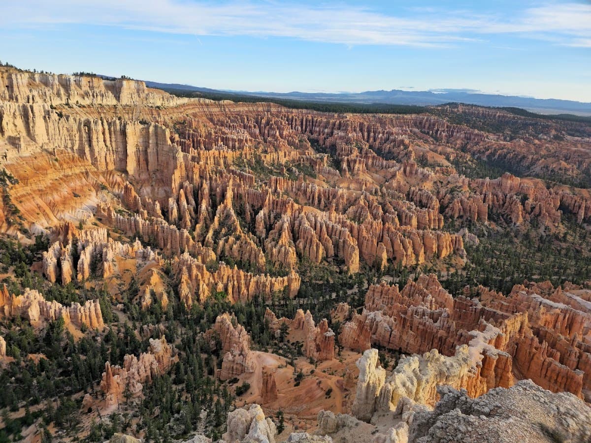
Bryce Canyon isn't actually a canyon at all. It's a collection of natural amphitheaters carved into the eastern edge of the Paunsaugunt Plateau, where millions of years of erosion created something that looks like Mars decided to throw a dinner party. The park's famous hoodoos – those towering red rock spires that look like stone soldiers standing at attention – stretch as far as you can see from the rim. But here's what the postcards don't tell you: the elevation here ranges from 8,000 to 9,000 feet, which means snow in winter and surprisingly cool mornings even in summer. Most visitors stick to Sunset Point and call it a day, but the real magic happens when you drop below the rim and walk among these geological giants.
Culture & Context
PAIUTE LEGEND PEOPLE
Bryce Canyon sits on the Paunsaugunt Plateau — a Paiute word meaning "home of the beaver." The Paiute people were here long before any settler, and they had their own name for the hoodoos: "Legend People," rock figures turned to stone. The park itself is named after Ebenezer Bryce, a Mormon pioneer who settled the area in the 1870s.
His famous (possibly apocryphal) assessment of the canyon: "It's a hell of a place to lose a cow." That irreverence is still present in the locals. Southern Utah around Bryce is deeply tied to Mormon pioneer heritage — the Panguitch Quilt Walk Festival literally commemorates pioneers who laid quilts on snow to walk across it during a desperate 1864 supply run.
The broader "Mighty 5" framing (Bryce, Zion, Arches, Canyonlands, Capitol Reef) dominates how visitors think about Utah, and locals know it. Expect a mix of deeply rooted ranch families, small-business tourism operators, and outdoor-sport transplants. Cell service is genuinely scarce inside the canyon.
That's not a complaint — it's part of the deal. The park sits at 6,800 to 9,115 feet elevation, which hits flatlanders harder than they expect.
Local Customs
LAYERS & LEAVE NO TRACE
Take the shuttle during peak season (May–September). Parking at Sunrise Point, Sunset Point, and Bryce Point fills by 9am. Circling for a spot is miserable and pointless when the free shuttle runs every 10–15 minutes from Ruby's Inn..
The Lodge at Bryce Canyon operates completely cash-free. Bring a card for everything inside the park.. Visitor Center hours are 8am–4:30pm, with extended hours in summer.
Rangers give daily geology talks and can tell you which trails are icy, muddy, or closed — worth a 5-minute stop before you head out.. Backcountry permits are issued in person only at the Visitor Center — you cannot get them online. If you're planning an overnight hike on the Under the Rim Trail (23 miles), plan to arrive early..
Pets are allowed only on paved surfaces: campgrounds, parking lots, paved viewpoints. Not on unpaved trails. Bryce Canyon is considered one of the less pet-accommodating parks in Utah — plan accordingly..
Dress in layers. The temperature swing between morning and afternoon can hit 50 degrees Fahrenheit. Snow in May is completely normal.
People get caught in afternoon thunderstorms every summer.. Leave No Trace is taken seriously here. The hoodoos are fragile limestone.
Going off trail or past safety railings is how people die — it happens almost every year.. RVs cannot park in Bryce Amphitheater lots between 8am and 8pm. If you're in an RV, arrive before 8am or park outside the park boundary and shuttle in.
Safety
ALTITUDE DEMANDS RESPECT
Elevation is the first thing to manage. The park runs from 6,800 to 9,115 feet. If you're coming from sea level, give yourself a day to adjust or expect headaches and fatigue on the trails.
Drink water constantly — the air is extremely dry and the sun is intense at altitude. Plan about a quart of water per hour of hiking. Water sources below the rim are limited and must be treated before drinking.
Footwear is not optional. Park officials cite improper footwear as the number one reason for rescue calls. Sandals and flat sneakers regularly send people to the rescue team.
The trails have loose rock and steep grade — wear proper hiking boots with traction. Temperature swings of up to 50°F between day and night are common. Bring layers even in July.
Afternoon thunderstorms roll in regularly during summer — check the forecast and get below treeline if lightning develops. Stay on marked trails. People die here almost every year from going off-trail or past safety railings.
The canyon rim drops steeply and eroded limestone is not stable. It looks solid until it isn't. Parking at major viewpoints fills by 9am in peak season — take the shuttle and skip the stress of watching people jockey for spots.
If you're visiting with an RV, confirm parking restrictions before pulling in (no amphitheater lots 8am–8pm). International visitors: the new 2026 $100/person surcharge applies on top of standard fees. The $250 international annual pass is a better deal for anyone doing more than one major park on the same trip.
Getting Around
SHUTTLE OR ARRIVE EARLY
Getting to Bryce Canyon requires a car. The closest major airports are Las Vegas (LAS) and Salt Lake City (SLC), both about 270 miles away. Cedar City Regional Airport (CDC) is 80 miles out and sometimes has cheaper regional connections.
There is no direct public transit to the park — rent a car at the airport, full stop. Once inside the region, the free NPS shuttle is excellent and genuinely worth using April through October. It runs from a staging area at Ruby's Inn in Bryce Canyon City, makes 15 stops over a 50-minute loop, and covers all the major viewpoints in the amphitheater area.
It does NOT serve the southern Scenic Drive past Bryce Point — you need your own vehicle for Rainbow Point and Yovimpa Point. Hours run 8am–6pm in April and October, 8am–8pm May through September. Frequency is every 10–15 minutes at peak times.
Free with your park pass. Show your digital pass (or America the Beautiful Pass) to the driver when boarding outside the park. Buy digital passes on Recreation.
gov before you arrive — it's faster than the entrance booth. Parking at amphitheater viewpoints fills well before noon in summer, often by 9am. If you're shooting sunrise, drive in early before the gates get busy or check if your accommodation is inside the park.
RVs cannot use the amphitheater lots between 8am and 8pm — park outside the boundary and shuttle in. The shuttle doesn't run in winter (November–March), so you're on your own with a vehicle during the off-season, which is honestly peaceful.
Useful Phrases
Money-Saving Tips
- 1.Buy the America the Beautiful Annual Pass for $80 if you're visiting more than 3 national parks this year
- 2.Pack your own lunch – the lodge restaurant charges $18 for a basic sandwich
- 3.Camp at Sunset Campground ($30/night) instead of staying at the lodge ($200+ per night)
- 4.Fill up your gas tank in Tropic or Panguitch – no gas stations inside the park
- 5.Visit during shoulder season (April-May or September-October) for lower accommodation rates
- 6.Bring your own water bottles – a single bottle costs $3 at the visitor center
Travel Tips
- •Start your hikes early – afternoon thunderstorms are common in summer
- •Download offline maps before you go – cell service is spotty throughout the park
- •The rim trail is paved and mostly flat, perfect for wheelchairs and strollers
- •Wear layers – temperatures can swing 30 degrees between day and night
- •Take the free shuttle during peak season to avoid parking headaches at popular viewpoints
- •Bring a headlamp for sunrise hikes – it's dark at 5 AM even in summer
- •Check weather conditions before hiking below the rim – flash floods are possible
- •The park elevation ranges from 8,000-9,000 feet – take it easy if you're coming from sea level
Frequently Asked Questions
BUILD YOUR
BRYCE CANYON NATIONAL PARK PLAN
Insider picks, smart timing, and a plan ready when you are.
Start Planning