Crater Lake National Park
America's deepest lake nestled in an ancient volcanic caldera
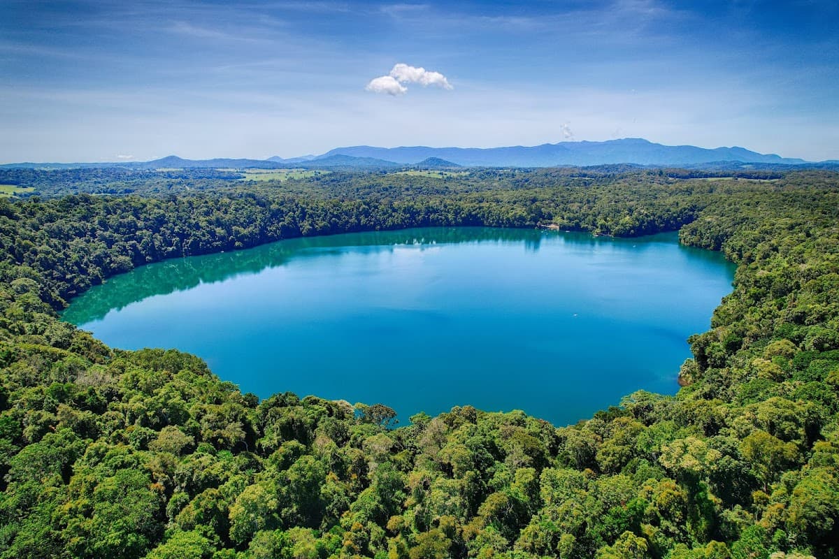
Here's the thing about Crater Lake: photos don't do it justice. This 1,943-foot-deep lake sits inside Mount Mazama's collapsed volcanic caldera, creating the kind of blue that makes you question your camera settings. The water is so pure you can see 30 feet down on a calm day.
Located in southern Oregon's Cascade Mountains, Crater Lake National Park draws half a million visitors annually. But here's what most people don't know — the park stays buried under 15 feet of snow until late June. That narrow summer window creates crowds, sure, but it also means you're experiencing something genuinely seasonal and special.
The 33-mile Rim Drive circles the caldera, offering viewpoints that'll have you pulling over every few minutes. And while the main attraction is obviously the lake itself, the park's 183,000 acres include old-growth forests, wildflower meadows, and hiking trails that range from easy lakeside strolls to challenging backcountry routes.
Culture & Context
SACRED KLAMATH WATERS
Long before any park ranger handed you a trail map, this lake was known as Giiwas by the Klamath Tribes — the Klamath, Modoc, and Yahooskin peoples — who understood what happened here 7,700 years ago better than any geologist would for millennia. Their oral tradition describes witnessing the catastrophic collapse of Mount Mazama (Moy-yaina, or "Big Mountain") into a caldera, and that story matches the geological record almost exactly. The lake was considered so sacred that tribal members kept its existence deliberately secret from outsiders for thousands of years.
When the Klamath Tribes signed the Treaty of 1864, Giiwas was supposed to be inside the protected boundary. It wasn't honored. On May 22, 1902, it became a national park.
The Klamath Tribes still hold the lake sacred and continue to ask visitors to approach it with respect. That context matters when you're standing at the rim. The park is also Oregon's only national park.
It sits in the Cascade Range of southern Oregon, reachable via Highway 62 from the west/south or US-97 from the east. The nearest city is Klamath Falls, about 37 miles south.
Local Customs
CARDLESS & SACRED
The park is fully cashless at entrance gates. Pay by card or pre-purchase a pass at Recreation.gov before you go.
Showing up with cash won't get you in.. Rim Drive is a one-way loop in sections — drive it clockwise. The speed limit is 35 mph on the narrow mountain road.
Don't rush it; it takes 2–4 hours with stops.. Bear-resistant food lockers are at every campsite at Mazama. Use them — every time, even for a quick hike.
Around 30–40 black bears live in the park.. Lodge rooms at Crater Lake have no TVs and no room phones by design. The whole operation is geared toward getting you outside and offline.
Plan accordingly.. Fishing is actively encouraged in Crater Lake. The fish (kokanee salmon and rainbow trout) were stocked non-natively starting in 1888 and now maintain a self-sustaining population.
No fishing license required inside the park.. Treat the lake with respect — this is still a sacred site to the Klamath Tribes. Keep noise down at overlooks, pack out everything you bring in, and stay on marked trails.
Leave No Trace isn't just a slogan here.. Make dinner reservations at the Lodge Dining Room at least a week in advance. Tables with lake views go to larger parties — couples often end up against the back wall.
If that bothers you, grab drinks and apps on the Great Hall terrace instead, which has some of the same views.. The park is operating with significantly reduced staff in 2026 due to federal hiring freezes and vacancies in key positions. Ranger-led programs are happening but the schedule is uncertain.
Check the NPS website before banking on specific programming.
Safety
STEEP VOLCANIC HAZARDS
2026 brings specific risks beyond the usual. The Cleetwood Cove Trail is closed and fenced off — do not attempt to reach the lake by descending the caldera walls anywhere else. People have done this and needed rescue. The cliffs are unstable volcanic rock and loose pumice. Construction vehicles are operating on sections of Rim Drive, particularly East Rim Drive beyond Skell Head. Use caution and watch for traffic if you hike or bike past the Skell Head gate. The park is operating with fewer rangers than normal in 2026 due to federal staff cuts and an ongoing hiring freeze for permanent positions, including the chief ranger role. That means slower emergency response times in remote areas.
General hazards year-round: weather changes fast at 6,000+ feet, and snow can fall any month including July and August. Pack warm layers even for summer hikes. Afternoon thunderstorms can roll in quickly. There is essentially no cell service in most of the park — tell someone your itinerary before heading into the backcountry. Black bears (30–40 in the park) are active; use bear-resistant lockers at all campsites. Unstable snow ledges extend beyond the rim edge in winter and early spring — the NPS has a short safety video about them on their website worth watching if you visit outside of peak summer season.
Getting Around
RIM DRIVE ONLY
There is no public transit to Crater Lake. A car is essential. From Medford (the nearest airport, served by major carriers) it's about 75 miles northeast on Highway 62 — roughly 1.5 hours depending on traffic and road conditions. From Klamath Falls, take US-97 north to Highway 62 west; about 55 miles and an hour. The south entrance via Highway 62 and the Annie Springs entrance station is the main approach.
Inside the park, Rim Drive is the main route — a 33-mile loop circling the caldera. Drive it clockwise. It's narrow and winding with a 35-mph speed limit. Budget 2–4 hours if you actually stop at viewpoints, which you should. Portions of East Rim Drive are currently closed due to rock slides and the road rehabilitation project.
A trolley tour runs from Rim Village in summer — it's a legitimate way to see the rim without the stress of driving narrow roads, and the onboard guide is knowledgeable. Worth it if tight parking or winding mountain roads aren't your thing.
The park entrance gates are cashless. Pre-purchase a pass at Recreation.gov or buy on-site by card. There is no cell service at the south entrance gate, so download or print your pass before arriving.
Useful Phrases
Money-Saving Tips
- 1.Buy the National Parks Annual Pass for $80 if visiting multiple parks — it pays for itself after three park visits
- 2.Pack your own lunch and snacks — the Crater Lake Lodge restaurant charges $18+ for basic sandwiches
- 3.Camp at Lost Creek or Mazama Village instead of staying at the lodge to save $150+ per night
- 4.Fill up your gas tank before entering the park — the Mazama Village station charges premium prices
- 5.Bring your own water bottles — the visitor center has free refill stations
- 6.Visit in late September for lower accommodation rates and fewer crowds while weather is still good
- 7.Download offline maps to avoid roaming charges — cell service is spotty throughout the park
Travel Tips
- •Start the Cleetwood Cove Trail early morning to avoid crowds and afternoon heat on the climb back up
- •Check road conditions before your trip — Rim Drive can close unexpectedly due to snow even in summer
- •Bring layers even in July — temperatures swing 30+ degrees between morning and afternoon
- •Park at major viewpoints fills by 10am on weekends — arrive early or visit midweek
- •The north entrance opens earlier in spring than the south entrance due to elevation differences
- •Wizard Island boat tours require hiking down to Cleetwood Cove first — plan 4+ hours total
- •Cell service is limited throughout the park — download maps and tell someone your hiking plans
- •Afternoon thunderstorms are common in summer — start long hikes early and watch the sky
- •The lodge's lobby has the best indoor lake views if weather turns bad
- •Sunrise at Watchman Peak requires a 30-minute hike in the dark — bring a headlamp
Frequently Asked Questions
BUILD YOUR
CRATER LAKE NATIONAL PARK PLAN
Insider picks, smart timing, and a plan ready when you are.
Start Planning